Across the border into Texas is the town of Shamrock. Shamrock is a city in Wheeler County, Texas located in the eastern portion of the Texas Panhandle centered along the crossroads of Interstate 40 – formerly U.S. Route 66 and U.S. Route 83. It is 110 miles or 180 kilometers east of Amarillo, 188 miles or 303 kilometers west of Oklahoma City, Oklahoma and 291 miles or 468 kilometers northwest of Dallas, Texas. In 1926, the discovery of oil and the operation of natural gas wells by Shamrock Gas Company helped spur the city’s continuing growth.

But a decline in the oil industry caused the population to drop in the 1940s, but it rebounded in the next decade with the improvement of Route 66. By the 1980s, the town was home to an established modern school system, a chemical plant, oil and gas processing plants, and a hospital. In 1936, the U-Drop Inn was built at the corner of the U.S. Route 83 and the now historic Route 66. At the time of opening, the U-Drop was the only café within 100 miles or 160 kilometers of Shamrock, enjoying good business and becoming a successful establishment.

Once considered a beautiful and impressive example of Route 66 architecture in Texas, the U-Drop Inn fell into disrepair with the decommissioning of Route 66. Referred to as “one of the most impressive examples” of Route 66 architecture by the Texas Historical Commission, the U-Drop Inn was added to the National Register of Historic Places in 1997. In May 1999, the First National Bank of Shamrock purchased the then closed U-Drop Inn and gave it to the city of Shamrock. With a $1.7 million federal grant, the city was able to hire a firm specializing in historical renovation to restore the building to its original glory and adapt it into a museum, visitors’ center, gift shop, and the city’s chamber of commerce. The revived U-Drop Inn was featured in the 2006 animated film Cars as the inspiration for the fictional Ramone’s body shop. The film industry paid another visit to shoot a scene at the end of the film Cast Away where Chuck Nolan, played by Tom Hanks, is seen Standing on US Route 83 near Interstate 40, the real-life location of Shamrock.

If you have timed your travels correctly, it will be time to stop in McLean, Texas at the Red River Steakhouse for lunch or dinner. But should you miss the Red River Steakhouse in Mclean – no need to fret as there is another now open in Amarillo, Texas just up the road. McLean is a town in Gray County, Texas where Alfred Rowe, an English rancher who later died in the sinking of the Titanic, donated land near a railroad cattle loading stop for the establishment of a town site in 1901. The Choctaw, Oklahoma and Texas Railroad Company constructed a water well and a switch and section house on the site and the town was named for Judge William P. McLean (1836–1925) of the Texas Legislature and Railroad Commission.

The town grew rapidly and by 1904 McLean had three general stores, a bank, two wagonyards and livery stables, a lumberyard, and a newspaper – the McLean News. A windmill pumped water from a well drilled in the middle of Main Street and citizens hauled the water in barrels and buckets. The town was incorporated in 1909 with C. S. Rice as mayor and became a center for agriculture. In 1927, Route 66 was built through the town, and it became a stop for tourists as well as a center for oil, livestock, and agricultural shipping.

By 1940 the population had risen to 1,500 with 6 churches, 59 businesses, and a newspaper. In 1942, a prisoner of war camp was built east-northeast of the town and was operated until 1945, housing about 3000 German prisoners. As the prominence of other Texas Panhandle cities, especially Amarillo and Pampa, surpassed McLean, the town began to decrease slowly in size and in 1984 the town was bypassed as part of the final phase of construction of Interstate 40, which replaced the old U.S. Route 66 through that area. The McLean Commercial District, consisting of most of the downtown area, was listed in the historical register on December 20, 2006 and the town is home to the Devil’s Rope Museum which displays everything you want to know about barbed wire and fencing tools.

From McLean travel on to Alanreed, Texas. Alanreed is an unincorporated community in Gray County, Texas named for Messrs. Alan and Reed, partners in the contracting firm that laid out the present townsite for the Choctaw, Oklahoma and Texas Railroad in 1900. An earlier name for the place was Gouge Eye, commemorating a nasty saloon brawl. Currently it has an excellent example of a typical Route 66 style gas station, a combination motel/truckstop/post office run by a good old girl named Dixie and leftover old buildings from earlier days.

In 1886 a post office called Eldridge was established six miles north of the present site of Alanreed. At various times throughout the years the town was also called Springtown or Spring Tank, for a large spring-fed tank – Prairie Dog Town, for one located closeby, and of course, Gouge Eye, for the notorious saloon fight. The present townsite was laid out in 1900 by a surveyor for the Choctaw, Oklahoma and Texas Railroad. The present name of Alanreed was supposedly derived from the name of the contracting firm, Alan and Reed.

In 1901 the first school was built. In 1902 the post office was moved from Eldridge and renamed Alanreed. After the Rock Island line was completed in 1903 the town became a shipping point for cattle. G. E. Castleberry’s land company sold parcels at $2.25 an acre and by 1904 Alanreed was the largest town in Gray County. In 1907 it had a bank, a hotel, a depot, a Baptist and a Methodist church, a saloon, two grocery stores, a hardware store, a livery stable, and a blacksmith shop. Watermelons became a major crop with the town shipping an average of 500 cars annually. In 1912 a two-story school was built. By 1917 the town had telephone service and an estimated population of 250.

Westward from Alanreed past the leaning water tank in Groom, Texas towards the city of Amarillo. Groom is a town in Carson County, Texas on Interstate Highway 40, formerly historic Route 66, 42 miles east of Amarillo and 220 miles or 350 kilometers west of Oklahoma City. The leaning water tower, which currently serves as a decorative item, was a functioning water tower which was slated for demolition until Ralph Britten bought it and moved it to serve as a sign for his truck stop and tourist information center located on a stretch of interstate that was once a part of U.S. Route 66. This truck stop can still be seen, set back off the road behind the tower, now boarded up and in disrepair following a devastating fire decades ago.

The leaning water tower still remains a popular target for cameras and the town of Groom turns on a large colored star mounted on the top at Christmas time. The water tower is a common image from most Route 66 photography books.

There is a 19 story tall cross located next to Interstate 40, formerly U.S. Route 66, at Groom. This 190-foot or 58 meter tall free-standing cross can be seen from 20 miles or 32 kilometers away. Surrounding the base of the cross are life-sized statues of the Stations of the Cross. Inspired by this cross, residents of Effingham, Illinois erected a similar cross that is eight feet taller. Many claim this cross to be the largest in the Western Hemisphere. However, it is smaller than the cross erected in the Valle de los Caidos in Spain. The cross is also 18 feet or 5.5 meters shorter than the 208 foot or 63 meter cross at the Mission Nombre De Dios in St. Augustine, Florida, and shorter than the 65 meter or 213 foot tall Lakeuden Risti cross-shaped church tower in Seinäjoki, Finland. The movie Leap of Faith was filmed on location near the site of the cross in Groom but the movie was filmed before the cross was built. The cross is not the tallest, but might be in the running for being the most tasteless. Its height achieved by using concrete and sheet metal, instead of the kind of materials generally used for monuments or tributes like stone or a cast metal like bronze.

Next along Route 66 heading westward aside from a truck stop on the highway on one side of the road and a copycat Cadillac Ranch made from old Volkswagens on the other is Amarillo, Texas. Ask any British resident about Amarillo and they’ll start singing the song written by Neil Sedaka and Howard Greenfield sung by Tony Christie – Is This The Way To Amarillo?

To watch the youtube video of Tony Christie singing the song, read the lyrics or send “Is This The Way To Amarillo” to your cellphone Click Here

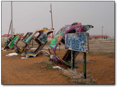
Amarillo is the fourteenth most populous city in the state of Texas, the largest in the Texas Panhandle and the seat of Potter County. The city was once the self-proclaimed Helium Capital of the World for having one of the country’s most productive helium fields. Amarillo is also known as The Yellow Rose of Texas, as the city takes its name from the Spanish word for yellow and was most recently dubbed Rotor City, USA for its V-22 Osprey hybrid aircraft assembly plant. Amarillo operates one of the largest meat packing areas in the United States. Pantex, the only nuclear weapons assembly and disassembly facility in the country, is also a major employer. The attractions Cadillac Ranch and the Big Texan Steak Ranch are located adjacent to Interstate 40. Cadillac Ranch is an art installation and sculpture outside of Amarillo, Texas that was created in 1974 by Chip Lord, Hudson Marquez and Doug Michels, who were a part of the art group Ant Farm, and it consists of what were, in 1974, either older running used or junk Cadillac automobiles. Different years and models represent a number of evolutions of the car – most notably the birth and death of the defining feature of mid twentieth century Cadillacs – the tailfins. The Cadillac tailfin was almost a trademark of the car from 1949 to 1963. These Cadillacs are buried halfway into the ground nose-first at an angle corresponding with that of the Great Pyramid of Giza in Egypt.
0 Shares